
ALERT Breaking Alert
UPDATE (Oct. 2, 7:25 p.m. CT)
The Flood Watch for Dallas–Fort Worth expired at 7 p.m. Friday, Oct. 2, and was not extended again. As of about 7:22 p.m. CT, the National Weather Service Fort Worth office no longer lists a Flood Watch on its watches page, and the national active-alerts feed shows no Flood Watch for DFW metro counties. The watch was not upgraded to a new area-wide Flood Warning for those counties.
Rain totals (NWS climate report for DALLAS/FT WORTH, via WeatherTotals as of Friday evening): DFW Airport recorded 3.47 inches on Thursday, Oct. 1, and 0.02 inches on Friday, Oct. 2 — about 3.49 inches for the storm through Friday. Fort Worth-area Thursday totals from NWS gauges (already reported): up to about 4.70 inches northeast of downtown Fort Worth, 4.05 inches at the NWS Fort Worth office near Haltom City, and 3.10 inches at a Fort Worth airport station.
Still in effect: a Flood Warning for the Trinity River at Dallas for minor flooding until late Friday night, per NWS Fort Worth.
The main flooding and road closures hit Thursday (including westbound I-30 near Chapel Creek in Fort Worth and high-water assists). Friday’s rain at the airport was only a trace-to-light 0.02 inches.
Sources for this close-out: NWS Fort Worth · NWS active alerts · NWS climate / WeatherTotals · FOX 4 · CBS News Texas.
UPDATE (Oct. 2, 9:27 a.m. CT)
The Flood Watch did not end Friday morning. It was extended. The National Weather Service in Fort Worth reissued it at 11:42 p.m. Thursday, and it now runs through 7 p.m. Friday, Oct. 2. The NWS says isolated additional rainfall totals of 2 to 4 inches are possible through Friday afternoon.
- Who’s in the watch now: Tarrant, Dallas, Denton, Collin, Johnson, Ellis, Parker, Hood, Rockwall, Kaufman, Hunt, Somervell and Erath counties, plus several counties to the south and east, per NWS. Northwest counties that were in the original watch, including Wise, Palo Pinto, Cooke, Grayson and Montague, are no longer listed.
- Warnings in effect (as of 9:27 a.m. CT, NWS): a Flood Warning for the Trinity River at Dallas, which had minor flooding at 32.2 feet at 7:30 a.m. (flood stage is 30 feet). The NWS says riverside bike trails could be under up to 2 feet of water, and expects the river to fall below flood stage late this afternoon. Flash Flood Warnings are also in effect south of the metro, for Bosque, Hill, Coryell and Lampasas counties, until 10:45 to 11 a.m.
- Thursday’s warnings: Dallas, Denton and Tarrant counties were under a Flash Flood Warning until 10:30 a.m. Thursday, the Star-Telegram reported. The NWS also issued a Flood Warning for Walnut Creek near Mansfield. A Flood Advisory for Dallas, Kaufman and Rockwall counties ran until 7 a.m. Friday.
- Rain totals:
- DFW Airport recorded 3.47 inches on Thursday, Oct. 1, plus 0.16 inch on Wednesday, according to the NWS climate report. That is more rain than DFW got in July, August and September combined, and Thursday ranks as the region’s ninth-wettest October day on record, CBS News Texas reported.
- The NWS Fort Worth office near Haltom City measured 4.05 inches in 24 hours.
- NWS reports through 3 p.m. Thursday: 4.70 inches at a gauge just northeast of downtown Fort Worth (the highest in Tarrant County), 3.10 inches at a Fort Worth airport station, 2.91 inches at NAS Fort Worth JRB, 2.95 inches at Dallas Love Field, 2.45 to 2.89 inches in Roanoke, and 1.94 inches near Justin.
- We did not find an official total for Alliance or Haslet.
- Flooding and road closures (NWS storm reports, Thursday):
- Westbound I-30 was closed near Chapel Creek, and NW 28th Street was closed west of I-35W.
- Underpasses flooded at Vickery and Pine.
- Streets flooded in the Diamond Hill and Westover Hills areas, and several vehicles were stalled in water on Hulen Street near Arlington Heights High School.
- Outside Fort Worth, there was flooding near Northlake’s Canyon Falls area, I-35E closures at Red Oak, and county road closures around Godley, Joshua and Cleburne.
- Water rescues: Fort Worth Fire responded to at least 20 high-water calls between midnight and 3 p.m. Thursday. Spokesperson Craig Trojacek told KERA there were “no true rescues,” with crews helping stalled drivers instead, and no flood deaths or injuries in the city. FOX 4 reported that Dallas Fire-Rescue made a water rescue Thursday.
- Other impacts: More than 7,500 customers lost power across Dallas, Tarrant, Denton and Collin counties Thursday afternoon, and more than 200 DFW Airport departures were canceled by 2:30 p.m., KERA reported. The Dallas Morning News reported that a Fort Worth school closed because of water getting into the building; the paper did not name it in the portion we could read. NBC 5’s school-closings page showed no closures or delays Friday morning.
- What’s next: More waves of rain are moving through Friday, and KRLD says the heaviest should wind down around sunset. A few showers are possible Saturday, with drier weather Sunday. Until then: Turn around, don’t drown.
Sources for this update: NWS Fort Worth watches · NWS river forecasts · CBS News Texas · KRLD · KERA · FOX 4 · Star-Telegram · Dallas Morning News · NBC 5. The original Sept. 30 alert follows below.
Breaking · Fort Worth · Sept. 30, 2026
We summarize. You read the outlet. Source: CBS News Texas on X · short original summary · full reporting at the source
A Flood Watch covers Fort Worth, Dallas and much of North and Central Texas from 4 p.m. Wednesday through 7 a.m. Friday as moisture from the remnants of Hurricane Polo brings slow-moving storms, the National Weather Service in Fort Worth says. Forecasters expect 2 to 4 inches of rain across the watch area, with 5 to 7 inches possible in some spots, on ground left bone-dry by months without rain. Turn around, don’t drown.
What the video shows
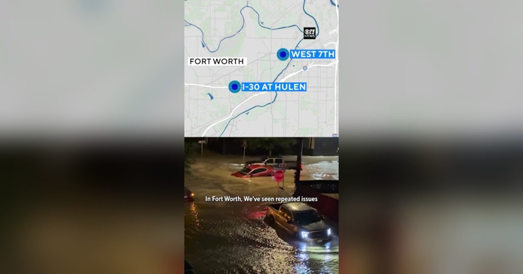
The 87-second CBS News Texas clip maps North Texas roads the station has seen flood before. It uses footage from past floods, not today’s storm. In Fort Worth, it points to the West 7th entertainment district near Forest Park Boulevard, where flash flooding hit in April, and to I-30 at Hulen. In Dallas, it points to Northwest Highway at Harry Hines, the area just north of Love Field, and Lawther Drive along the northeast edge of White Rock Lake. The clip ends with officials’ advice: never drive into flooded roads, and have a way to get weather alerts.
The watch
- When: 4 p.m. Wednesday, Sept. 30, through 7 a.m. Friday, Oct. 2, according to the National Weather Service in Fort Worth.
- Where: 36 North and Central Texas counties, mainly along and west of I-35: Tarrant, Dallas, Denton, Collin, Parker, Johnson, Ellis, Wise, Hood, Rockwall, Kaufman, Hunt, Palo Pinto, Somervell, Erath, Jack, Young, Montague, Cooke, Grayson, Fannin, Stephens, Eastland, Comanche, Mills, Hamilton, Bosque, Hill, Navarro, Lampasas, Coryell, Bell, McLennan, Falls, Limestone and Milam.
- How much rain: The NWS says slow-moving storms will likely bring 2 to 4 inches of rain across the watch area, with 5 to 7 inches possible in some spots. The City of Fort Worth said it expects 2 to 5 inches across town, with up to 8 inches possible where storms repeat, and put the city at a high flash-flood level for Wednesday and Thursday, KRLD reported.
- Storms, too: A few severe storms Wednesday evening could bring hail and damaging wind, according to FOX 4 and KRLD. A cold front arriving Friday is expected to clear the storms and bring highs in the upper 70s to low 80s over the weekend.
- Why it matters: The rain is tied to moisture from the remnants of Hurricane Polo. It falls on ground that is unusually dry after months with almost no rain, so water can run off fast. DFW Airport went 67 straight days without measurable rain this summer, KRLD reported. CBS News Texas reported that Lovejoy ISD has already canceled its homecoming parade scheduled for Wednesday evening.
Stay safe: Turn around, don’t drown
- Never drive or walk into flooded roads. The NWS says just 6 inches of fast-moving water can knock over an adult, and 12 inches of rushing water can carry away most cars. Turn around, don’t drown.
- Watch vs. warning: A watch means flooding is possible. A warning means it is happening or about to. If a Flood Warning or Flash Flood Warning is issued for your area, move to higher ground.
- Before the rain: Move cars out of low-lying areas, and stay away from creeks and the Trinity River, as Fort Worth officials urged.
- Stay alerted: Turn on emergency alerts on your phone, and have a backup way to get warnings overnight.
- Known trouble spots: Be extra careful at low-water crossings and in places that have flooded before, like those in the CBS video.
Known vs. unconfirmed
- Known: The Flood Watch and its times, counties and rainfall range come from the NWS Fort Worth office’s latest bulletin, issued at 4:40 a.m. Wednesday and still in effect as of 10:41 a.m. CT.
- Still uncertain: Exactly where the heaviest storms will set up, and whether any flood warnings will follow. Forecasts will change. Check the NWS and local stations for updates.

